Thursday, July 28, 2011

July 27 - Ninilchik

Our Internet is real slow here, so we'll put more info up on our visit to the Kenai Peninsula and halibut country later.  We're staying at the Deep Creek State Park, right on the Cook Inlet with several volcanoes about 30 miles across the bay. It's about 30 miles north of Homer, Halibut Capitol of the World.

Loons, eagles, and a great sunset behind a distant volcano, Mt. Redoubt.


Another Volcano, Mt. Iliamna, across the Inlet.


Halibut charter on Saturday and we're hoping to catch some big ones - like this 160 pounder in the middle!  They call the big "barn doors" because that's what it's like reeling one in, or "shooters" because they have to shoot them before they can haul them in the boat.

Saturday, July 23, 2011

July 22 to 24 - Valdez is Great!

The Allison Point Campground isn't much to look at, but everything around it is.  Nothing like having a waterfront campsite! 


Even cell phone service - with a view!


Here are some pics of the town.  Not too big of a place, but they have a Safeway, more than two gas stations, and a hardware store.


....and lots and lots of fishing boats.


Anyone watch Deadliest Catch?


All day long we can look out and see eagles, sea lions, otters, and bears.  The eagles seem to like to sit up above everyone and take it all in - until they are hungry anyway.  Then they fly out and snatch a fish, hoping the darn seagulls don't steal it.

 
The sea lions will catch a salmon and come to the surface and shake the daylights out of it.


The seagulls hang around to get the leftovers.


 Otters are better known for eating shellfish, but the ones here don't seem to mind salmon at all.  Again, the pesky seagulls just can't leave anything with a fish alone.


They are all taking advantage of the salmon that are packed into the Prince William Sound to start their spawing run.  The fish are hatchery fish though, so unfortunately for them the run upstream is a short one, and they hit a dead end at the hatchery.  This is a picture of the weir they pass on their way upstream.


 This area is pretty much the end of the line for them.  At least it has a view too!


Time to Go Fishin'!

Fishing here in Prince William Sound is about as fun as it gets.  The limit is 6, and you can easily catch a limit in under an hour.  So we caught and released quite a few, but still took our limit of pink and sockeye salmon to stock up the freezer.

A entrepreneurial kid a few campsites down collects lost lures at low tide, so we bought a couple of the "secret baits" from him at bargain prices.  (BTW the secret baits are Pixie Spoons, but these fish would probably bite a painted rock....)


Didn't take long to get the first fish.


...or the second...


 ...or a limit!


 This little guy really wanted to help us land our fish.  He was having a ball catching them too!
 
 And of course we had to go again the next day for another limit.


Wow, fresh salmon for dinner two days in a row.  Hopefully we'll have some left in the freezer when we get back to Michigan.


It didn't take long to figure out the bear's schedule.  At about 8:00 each evening, he, or she, comes out for dinner.  We were able to get this video of it catching a fish and making off with it.  Pretty exciting!
 

Valdez has been about the best stop yet, but the weather forecast is not too good for the next couple days.  So we'll probably head out for the Kenai Peninsula for a cruise and hopefully some halibut fishing on Sunday.  Might have to try for 6 more salmon here in Valdez first though!

July 21 - The Drive to Vadez

On Thursday we finished the Top of the World highway.  One thing we began to notice is that Alaska is very BIG.  The mountains are huge and far away, you can just plain see a long way.


We stopped in Tok to fill up with cheap diesel, well if you call $4.69 a gallon cheap, and a stop at the visitors center to pick up more Alaska info.


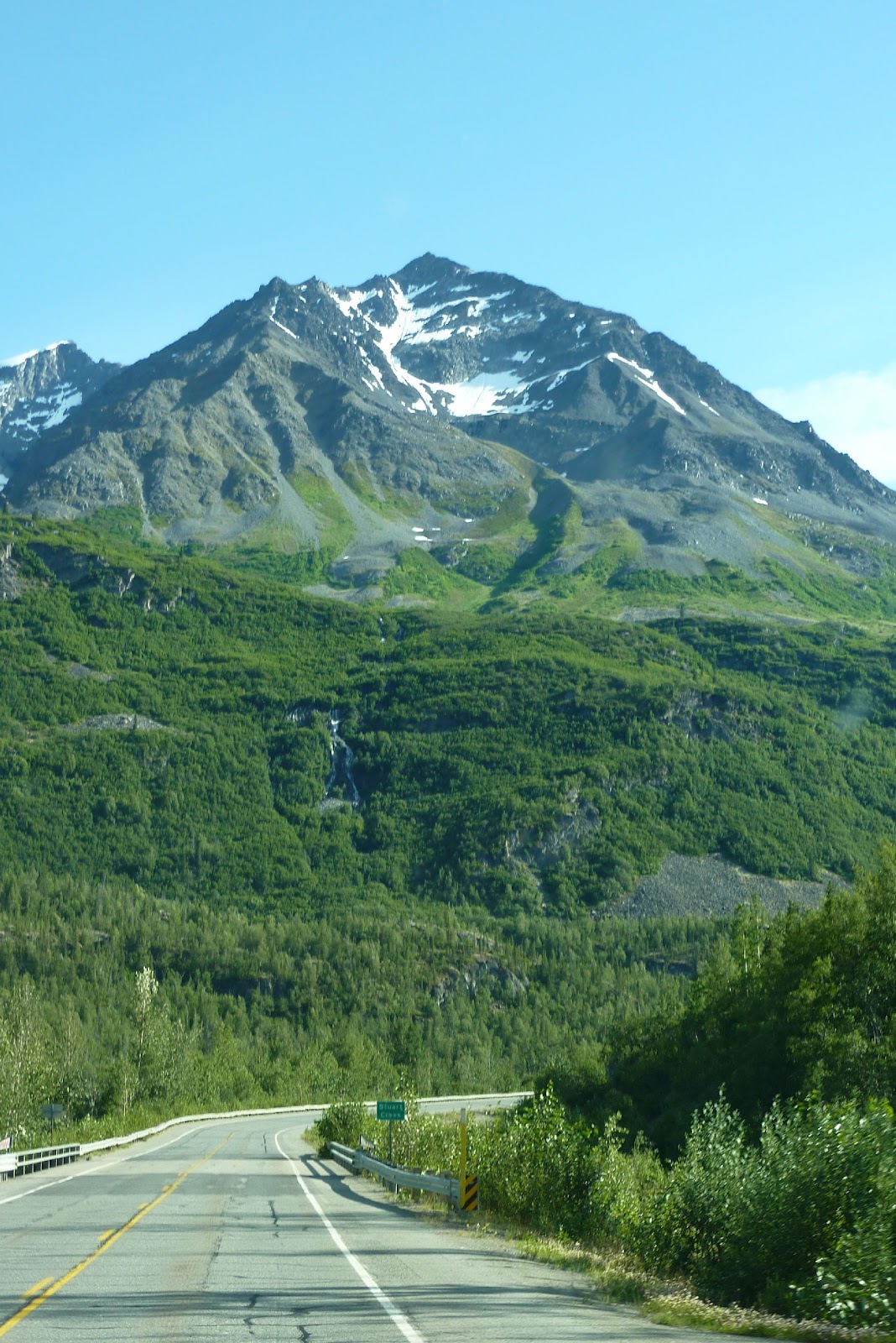
Then we were on our way to Valdez.  The drive to Valdez is unbelievable. 


First, there are views of the mountains in the Wrangle-St. Elias National Park.  A couple of the mountains here are over 16,000 feet, and Mt. Wrangle is an active volcano, with steam visible coming out of it on a clear, calm day.  It was a nice day, but still some clouds blocked the top of the mountains from view. 


We finally did see the clouds clear around McCarthy, and got a good pic of Mt. Wrangle. 
Couldn't tell if there was steam coming out though.


As we got closer to Vadez, about 50 or 60 miles north, the views got really breathtaking. 


Here's some fireweed in full bloom along the road.  It is thicker here than anywhere we've been so far.


Lots of tall, craggy mountains filled with snow, glaciers, and waterfalls.


We followed this helicopter, watching it land and take off along the road a couple times.  Too bad they didn't flag us down for a ride with them over the glacier.


Turns out this is named the Worthington Glacier and there was a pull out, so we decided to stop. 


It ended up being a long stop, because we couldn't resist taking a walk up to the glacier, hoping to actually touch one.


A view from a ways up the glacier.


Our first time to touch a glacier.  This is actually a large piece of ice.  Roxane is touching a spot where we wiped the dirt away.

A couple more views from high up.


Just down the road from the glacier,  we pulled out to check out the scenery at Thompson Pass - elevation about 2,750 feet.  More great views!


Click on this panorama to check it out.


2,750 feet doesn't sound very high, but knowing Valdez is at sea level, we knew it would be a long and steep downgrade to Valdez.  But again, the scenery just kept getting better, the road wound between mountains that rose straight up from the road.  Pictures just wouldn't do this drive justice.  And of course there were waterfalls!


Once at the bottom, we started looking for the Allison Point State Park Campground.  It's right on the Prince William Sound, across from the City of Valdez.  As we drove around the sound, there were bald eagles flying around everywhere.  We pulled off to check the view ourselves and spotted this crossing the road behind us...our first grizzly bear!


It looked like a young bear, and it went right down to the water to catch some dinner.  What a great sight to end the day!

July 20 - Top of the World Highway

After a rainy day on Tuesday, we got lucky with a beautiful sunny day for our trip across the Top of the World Highway.   The first stop was the ferry, which is the only way to cross the Yukon River to head west from Dawson City.  We wondered how this would go with our truck and trailer being about 53 feet long, but there was room for us plus a few cars and motorcycles.


Once we got to the other side, it was a long uphill climb.  We spotted one fox along the way (blurry pic though), but other than that no critters.  The views were great though, and the road all the way to the US border was pretty good and mostly paved.  Goodbye Dawson City!


We spotted a few old cabins like this along the way.


The Top of the World Highway pretty much follows along the tops of the mountains, especially on the Canada side.


There was a pull-out at the very top.  A short hike to the top of a hill and we really felt like we were on the Top of the World.


Just past US Customs, we came to the first town in Alaska - appropriately named Boundary.  Looked like a pretty lonely place, but they probably like it that way.


Right away the road got real bumpy.  Full of potholes pretty much for the whole 42 miles to Chicken.  We found ourselves slowing down to 2 or 3 mph quite a bit so we didn't break something. 


The views were great though.  Here's a view of Wade Creek from pretty high up.  Luckily there wasn't much traffic, because there were some pretty steep drop-offs right at the road edge that we for sure didn't want to get close to. 


We finally met some workers grading the road.  Were we glad to see them!  Unfortunately, there weren't enough of them and the road got real bumpy again.


At one point along the way, we stopped to help a couple that had a locked up front brake.  After about an hour, their caliper was off and wired up out of the way.  He had about 100 miles of rough, mountain road driving to get to Dawson City, but off they went anyway with one front brake. Hope they made it!

We rolled into Chicken, Alaska and stopped for a bit of fuel, dinner (what else - chicken sandwiches!) and a stroll through the gift shop.  There were campgrounds there too, but we decided to keep going for a while.


Just outside of Chicken, we finally got some paved road, well mostly paved.


We ended up stopping at the Walker Fork Campground, between Chicken and Tok.  It is run by the BLM (Bureau of Land Management).  No hookups, but a nice camp with trees and lots of space between campsites.  A nice change from the private, parking lot style private campgrounds.  They even had a "moose pond", but we never did see the moose.  A nice little campfire and we were ready to turn in after a tough 150 mile day.