We left Seward on Wednesday, hoping that we could get away from the wet weather, but the rain followed us. We set up camp at the Williwaw National Forest Campground on Portage Glacier Road and drove the mile or so to the Begich-Boggs Visitor Center for the Portage Glacier. We're about 50 miles southeast of Anchorage.
The wind was blowing so hard (about 60 mph!) at the Visitors Center, we could hardly get from the truck to the building. It was like being in a hurricane! And as it turns out the Portage Glacier area is in what the NP Ranger told is a "vortex" for winds coming between the mountains and off the Prince William Sound to the west. And we hit it on an exceptional day.
Here's pic of the Portage Glacier, which as it turns out is the most visited glacier in Alaska. They even have a tour boat that goes across the lake to the base of the glacier, where there are icebergs falling off the face of it. This is a must see area for anyone thinking of going to Alaska, so click HERE for some more info.
On Thursday, we awoke to rain again. So we loaded up and drove west about 4 miles to visit Whittier. The only way to get there is through a 2.5 mile long tunnel, which is billed as the longest combined railroad and vehicle tunnel in North America. It is only one lane, so there are westbound times, eastbound times, and train times. Here we are driving up to the toll booth to shell out our $12 toll. Whew, at least we only have to pay one way!
And we get in our assigned lane and wait for the green light.
Then we're off!
The tunnel is like a mine. Not a very good pic here, but you can see the train tracks going down the middle.
2.5 miles later and we're at Whittier. Still raining - surprise!
Whittier was hopping during WWII. It was a major supply point for battles in the Alutian Islands and other Pacific areas. In 1964, it was all but destroyed by the largest earthquake (9.2 on the Richter Scale) recorded in North America. The earthquake was centered in the middle of Prince William Sound and caused a 20 or 30 foot tsunami that flattened all the town except for the higher ground and the heavy-duty concrete buildings constructed during WWII.
Now it is mainly a tourist, fishing, and there's a lot of shipping activity due to its proximity to Anchorage and the railroad access
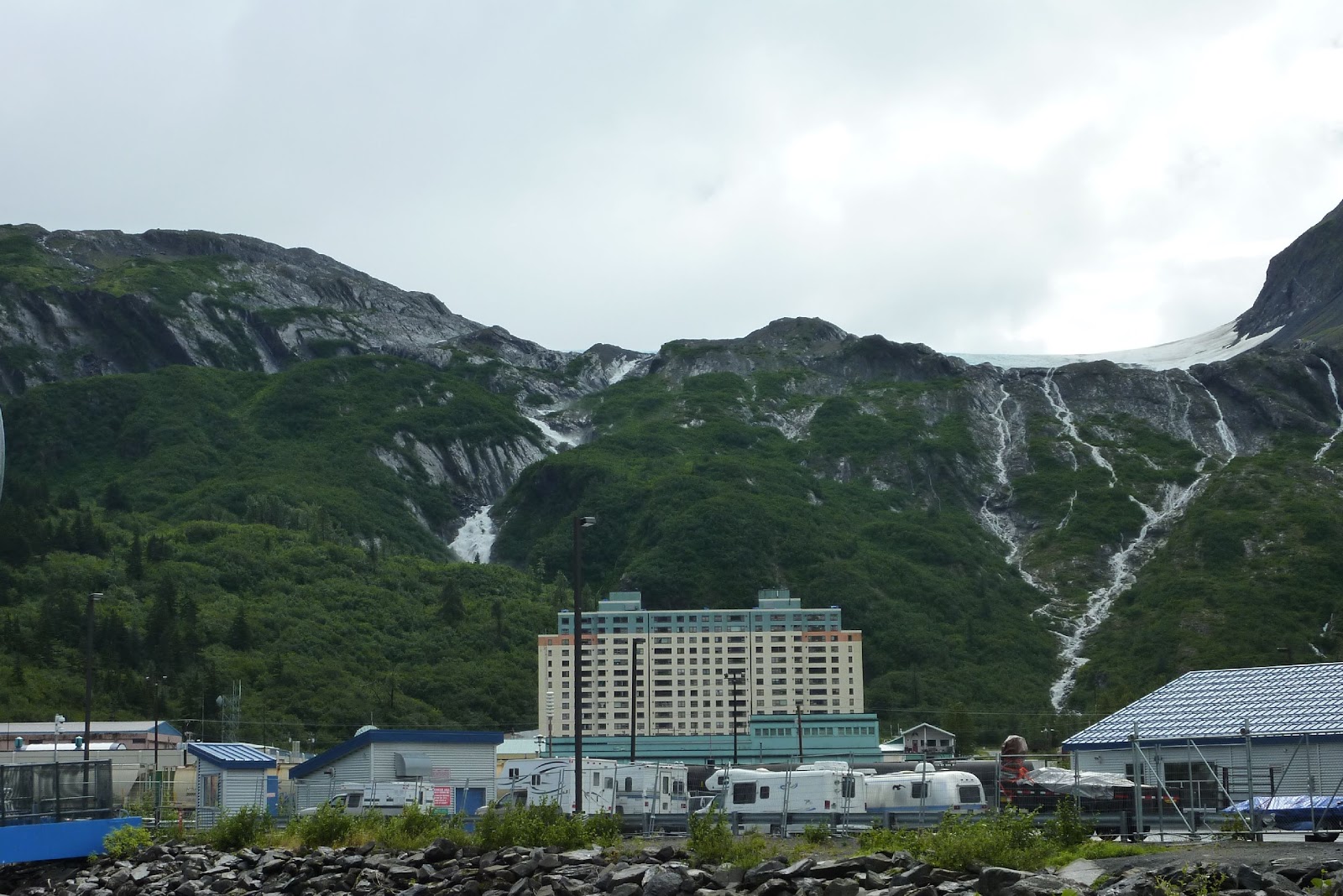
One good thing about rain is that it makes great waterfalls. The large building is one of the WWII leftovers that is now apartments where most of the permanent residents live.
Here's a view of the small boat harbor.
It's also a stopping point for the Alaska Marine Highway. You can drive your car, RV, or motorcycle onto a boat like the blue and white one on the right and sail all the way back and forth to Seattle, with stops along the way.
While in Whittier we made a much-needed stop at the only laundromat in town and visited the gift shops. One of the shopes had fudge and reminded us of Mackinaw, so Roxane just had to have some. We got to talk with a fellow Spartan for a while who worked there and on the Marine Highway boats for the summer. There are a lot of people that come to Alaska to work for the summer, then return to the lower 48 for the winter. The pay is very good, but the hours are long and there isn't any time for them to see the sights.
After the return trip through the tunnel, we took a 1 mile hike to the Baxter Glacier. We just can't seem to get enough of these things. Each one is different. This one was a beautiful baby blue color and had some cool ice caves where the water flowed at the base.
Greg couldn't resist some rock-hopping to get close the the huge cave where the stream came out of the glacier. Didn't want to get wet feet though - this water is cold!
And Roxane just had to have another rock momento. Greg says "is this the one?"
One our way back, we spotted this ominous sign of fall. We also noticed a lot more of the fireweed plants are flowered out at the top of the plant. They say that when this happens, there is only 6 until winter. We will hopefully be gone by then!
We spotted this chunk of blue glacier ice floating in Portage Lake on our way out.
Back at the campground, this is our view of the waterfall flowing out of a glacier that we listen to all night long. This has been one of the most scenic spots and nicest campgrounds we've stayed in. No hookups or TV reception, but it's private and the surroundings are great.
This is all about Roxane and Greg's trip to Alaska, and lots of places in between, from June to September. We hope our family and friends will follow along to share the sights and experiences. Enjoy!
Sunday, August 7, 2011
Wednesday, August 3, 2011
August 2 (and 3) - Getting Wet in Seward
We went over to catch our tour boat at 9 am, only to find out that the tour likely wouldn't make it out to the gulf and to the tidewater glaciers due to 10 foot waves. Seeing those glaciers that calve ice into the water, and the chance of seeing some whales, was our real reason for taking the tour. So between that and not wanting to risk another case or two of seasickness, we decided to cancel the trip and get a refund. Waves are predicted to be 14 feet tomorrow and 8 feet the next, so it doesn't look like we'll get another chance.
We decided to just hang around Seward and take in the Alaska Sea Life Center. It's the only aquarium in Alaska. The had a lot of real nice displays of Alaska sea life - fish, crabs, plus a aviary with some of those cool-looking puffins. We could have watched these guys for hours. This is a Tufted Puffin that hung out at the edge and seemed to have fun splashing folks and getting his picture taken.
There's another kind called a Horned Puffin because of the lines above his eyes.
We also were impressed with Woody, the Stellar Sea Lion. Woody is a big dude and weighs in at 1,700 pounds! We think this is the kind of seal we watched catching salmon at Valdez.
After a wet walk through town, we spent the rest of the evening holed up in the trailer, listening to the rain and wind. One of the locals told us this is their first big fall storm. Yipee! We're hoping for a quick and long Indian Summer now.
We've also found a couple spots on the trailer that can't quite keep out all this water. So time to get out the silicone sealer if we can find some dry weather.
We'll be working our way north to Anchorage the next couple days. Son Matt is flying in on Friday and then we're heading up to Denali for 8 or 10 days.
We decided to just hang around Seward and take in the Alaska Sea Life Center. It's the only aquarium in Alaska. The had a lot of real nice displays of Alaska sea life - fish, crabs, plus a aviary with some of those cool-looking puffins. We could have watched these guys for hours. This is a Tufted Puffin that hung out at the edge and seemed to have fun splashing folks and getting his picture taken.
There's another kind called a Horned Puffin because of the lines above his eyes.
We also were impressed with Woody, the Stellar Sea Lion. Woody is a big dude and weighs in at 1,700 pounds! We think this is the kind of seal we watched catching salmon at Valdez.
After a wet walk through town, we spent the rest of the evening holed up in the trailer, listening to the rain and wind. One of the locals told us this is their first big fall storm. Yipee! We're hoping for a quick and long Indian Summer now.
We've also found a couple spots on the trailer that can't quite keep out all this water. So time to get out the silicone sealer if we can find some dry weather.
We'll be working our way north to Anchorage the next couple days. Son Matt is flying in on Friday and then we're heading up to Denali for 8 or 10 days.
August 1 - Seward Day 1
Arrived in Seward yesterday and looked around to see where everything was at. We booked a glacier/wildlife cruise for tomorrow, so hoping the weather holds out. Seward is a nice town, but pretty expensive for everything. It would be a lot nicer with less clouds and rain, but that's Alaska in August we hear.
We drove over to check out Exit Glacier, just north of town. It is within the Kenai Fjords National Park and just one of the many glaciers fed by the Harding Ice Field, which covers 300 square miles. After a stop at the visitor center, we walked up to the overlook of the bottom of the glacier and the outwash plain.
Glaciers are real blue on cloudy days, even close up. It taked 100 feet of compacted snow to make 10 feet of glacier ice!
We decided to take a hike up the Harding Ice Field Trail. At around 4 miles and a 3,000 foot elevation gain one way, we didn't plan on making it all the way, but hoped to make it to the Cliff Overlook about half way. It was drizzling rain and the trail was pretty steep going up. We ended up in the clouds, but could still see all the wildflowers and views of the glacier now and then.
Here are some lupine. Roxane wanted this pic for here computer desktop background.
We made it to the first overlook and watched some ice hikers crossing the crevasses in the glacier.
Walking across these tied onto six other people didn't look like something we wanted to do. But some other hikers that we talked to convince us to go a bit further to the Cliff Overlook for a good view of the glacier. By the time we climbed what seemed like another 1,000 feet straight up, we were really in the clouds and had to wait for them to pass to get a good view.
Sun would have been nice though, it was still pretty cool and rainy at about 2,500 feet of elevation. We had enough climbing though, so headed back down. The hike down was only a bit easier and we were glad when it was over.
Back at the trailer, nursing our sore backs and knees, we watched this eagle having some dinner while a tour boat like the one we are supposed to be on tomorrow went by.
We drove over to check out Exit Glacier, just north of town. It is within the Kenai Fjords National Park and just one of the many glaciers fed by the Harding Ice Field, which covers 300 square miles. After a stop at the visitor center, we walked up to the overlook of the bottom of the glacier and the outwash plain.
Glaciers are real blue on cloudy days, even close up. It taked 100 feet of compacted snow to make 10 feet of glacier ice!
We decided to take a hike up the Harding Ice Field Trail. At around 4 miles and a 3,000 foot elevation gain one way, we didn't plan on making it all the way, but hoped to make it to the Cliff Overlook about half way. It was drizzling rain and the trail was pretty steep going up. We ended up in the clouds, but could still see all the wildflowers and views of the glacier now and then.
Here are some lupine. Roxane wanted this pic for here computer desktop background.
We made it to the first overlook and watched some ice hikers crossing the crevasses in the glacier.
Walking across these tied onto six other people didn't look like something we wanted to do. But some other hikers that we talked to convince us to go a bit further to the Cliff Overlook for a good view of the glacier. By the time we climbed what seemed like another 1,000 feet straight up, we were really in the clouds and had to wait for them to pass to get a good view.
Sun would have been nice though, it was still pretty cool and rainy at about 2,500 feet of elevation. We had enough climbing though, so headed back down. The hike down was only a bit easier and we were glad when it was over.
Back at the trailer, nursing our sore backs and knees, we watched this eagle having some dinner while a tour boat like the one we are supposed to be on tomorrow went by.
Monday, August 1, 2011
July 30 - Ninilchik Halibut Fishing
We had to get up early for a change to make it to the charter office by 8:00. Dressed up in about 4 layers, including the long johns, expecting it to be a bit cool on the water.
They launch the charter boats at the same park we are camped in. The tow vehicles unhook, we all climb in the boat, then one of these rigs, operated by the "water boys", tow the boat and trailer across the beach and push the boat out into the water.
This isn't our boat, just one of the 2 dozen or so that go out of Ninilchik every day.
The tide was not really in our favor today. Because of the moon phase, the change in water level between high and low tides in the Cook Inlet is about 23 feet! The water goes down so low that they call it the "Clam Tide". So there were a lot of people that came in to dig razor clams.
The problem it causes with fishing is that the current goes in and out so fast that we would only have a a couple of hours of "slack tide" to fish while anchored. While the tide is going in and out, even with a 4 pound sinker, the bait just wouldn't stay on the bottom.
The captain ran the boat south for about an hour and a half. We passed puffins and sea otters along the way. The further south we got, the rougher it got. When we started hitting some 7 foot waves, we had to turn back north for some calmer water. Here's our sister ship anchored not far from us.
The waves here were still rolling at 4 or 5 feet, and it didn't take long for a couple of people on the boat to get sea-sick. Everyone was fine until the poles hit the water, then looking down at the end of the pole to see the bites got them. Unfortunately, one of them was Roxane, even though she took a dramamine before we left.
After a bit of fishing and a couple small halibut, Captain Brian (from Romulus, MI and still spends 3 or 4 months a year there) decided to get us north to some calmer water before any more of us got sick. Still not much luck though. It wasn't long before the tide started coming back in and the only choice was plan C, which stands for hitting the "chicken hole" to at least get our fish, even though chances of getting a big one would be slim to none. So we drifted through the hole, picked up and ran back up to the top, and drifted through it again, and again, and again. Roxane started feeling better and fished some, but drifting at 4 knots with 6 lines hanging off the boat made for lots of tangled lines and it was tougher to feel a bite before they stole the bait.
It took longer that it should have, but we finally got our limit of 12 fish, plus one for Captain Brian. The guy that got sick, Zak from Utah, actually got the biggest fish, about 20 pounds, still pretty small by halibut standards. Greg ended up catching 4 big old cod (no good because they are full of worms), a shark, and 7 halibut, 5 of which went in the box. After what really was a tough day of fishing, we were all happy to get our fish, even if they were all the "ping pong paddle" variety.
We got back to the camp and bagged up the fish and realized that getting small fish was actually a good thing. Between the food we had in it, the salmon we caught in Valdez, and now 4 1/2 halibut (Capt. Brian gave us half of his), the freezer in our fifth wheel was totally full. We even had to pull out a couple things and put them in the fridge.
We are leaving Ninilchik tomorrow, heading for Seward, which is on the other side of the Kenai Peninsula. We really enjoyed ourselves here at the Deep Creek State Park Campground. We had a perfect spot to camp, walk the beach, and watch sunsets over smoking volcanoes. At 5 nights, it was the longest time we've spent in one place so far.
Our last sunset here was suitable for framing!
And that darn low "clam tide". Guess we'll have to come prepared for clamming next time!
One other thing we didn't get around to was picking a batch of sea peas. They are pods full of small peas that are cooked by just steaming/sauteeing the whole thing like you would green beans or asparagus. They grow wild all over the place near the water. Here's a pic for folks that might want to pick some on their trip to Alaska. The purplish pods aren't quite ripe yet - gotta wait until they are mostly green. The purple flowers make the plants easy to spot.
On to Seward, and rainy weather according to the weather reports.
They launch the charter boats at the same park we are camped in. The tow vehicles unhook, we all climb in the boat, then one of these rigs, operated by the "water boys", tow the boat and trailer across the beach and push the boat out into the water.
This isn't our boat, just one of the 2 dozen or so that go out of Ninilchik every day.
The tide was not really in our favor today. Because of the moon phase, the change in water level between high and low tides in the Cook Inlet is about 23 feet! The water goes down so low that they call it the "Clam Tide". So there were a lot of people that came in to dig razor clams.
The problem it causes with fishing is that the current goes in and out so fast that we would only have a a couple of hours of "slack tide" to fish while anchored. While the tide is going in and out, even with a 4 pound sinker, the bait just wouldn't stay on the bottom.
The captain ran the boat south for about an hour and a half. We passed puffins and sea otters along the way. The further south we got, the rougher it got. When we started hitting some 7 foot waves, we had to turn back north for some calmer water. Here's our sister ship anchored not far from us.
The waves here were still rolling at 4 or 5 feet, and it didn't take long for a couple of people on the boat to get sea-sick. Everyone was fine until the poles hit the water, then looking down at the end of the pole to see the bites got them. Unfortunately, one of them was Roxane, even though she took a dramamine before we left.
After a bit of fishing and a couple small halibut, Captain Brian (from Romulus, MI and still spends 3 or 4 months a year there) decided to get us north to some calmer water before any more of us got sick. Still not much luck though. It wasn't long before the tide started coming back in and the only choice was plan C, which stands for hitting the "chicken hole" to at least get our fish, even though chances of getting a big one would be slim to none. So we drifted through the hole, picked up and ran back up to the top, and drifted through it again, and again, and again. Roxane started feeling better and fished some, but drifting at 4 knots with 6 lines hanging off the boat made for lots of tangled lines and it was tougher to feel a bite before they stole the bait.
It took longer that it should have, but we finally got our limit of 12 fish, plus one for Captain Brian. The guy that got sick, Zak from Utah, actually got the biggest fish, about 20 pounds, still pretty small by halibut standards. Greg ended up catching 4 big old cod (no good because they are full of worms), a shark, and 7 halibut, 5 of which went in the box. After what really was a tough day of fishing, we were all happy to get our fish, even if they were all the "ping pong paddle" variety.
We got back to the camp and bagged up the fish and realized that getting small fish was actually a good thing. Between the food we had in it, the salmon we caught in Valdez, and now 4 1/2 halibut (Capt. Brian gave us half of his), the freezer in our fifth wheel was totally full. We even had to pull out a couple things and put them in the fridge.
We are leaving Ninilchik tomorrow, heading for Seward, which is on the other side of the Kenai Peninsula. We really enjoyed ourselves here at the Deep Creek State Park Campground. We had a perfect spot to camp, walk the beach, and watch sunsets over smoking volcanoes. At 5 nights, it was the longest time we've spent in one place so far.
Our last sunset here was suitable for framing!
And that darn low "clam tide". Guess we'll have to come prepared for clamming next time!
One other thing we didn't get around to was picking a batch of sea peas. They are pods full of small peas that are cooked by just steaming/sauteeing the whole thing like you would green beans or asparagus. They grow wild all over the place near the water. Here's a pic for folks that might want to pick some on their trip to Alaska. The purplish pods aren't quite ripe yet - gotta wait until they are mostly green. The purple flowers make the plants easy to spot.
On to Seward, and rainy weather according to the weather reports.
July 29 - Motorcycling Some More - South to Homer
Homer is about 35 miles south of Ninilchik, so a much shorter ride today. We started out on the Skyline Drive for a bird's eye view of Homer and the Homer Spit. What a view!
And a zoom-in on the end of the Spit...
While the main part of town is up on the high ground, the Spit is for the tourists. It's full of shops, restaurants, and fishing charter services. Pretty neat place, like most tourist traps.
We also took a drive about 25 miles east of town on what else - East End Road. The rode climbed up to give a great view of Kachemak Bay and the mountains and glaciers on the other side. Found a nice place to stop for some pics.
The long days here make for some BIG wildflowers too.
Roxane even found a nice patch of bear grass that posed for her.
And right in the middle of town, an eagle's nest with the younguns (yep there's two) watching the cars - and motorcycles, go by.
Tomorrow it's finally time for some halibut fishing!
And a zoom-in on the end of the Spit...
While the main part of town is up on the high ground, the Spit is for the tourists. It's full of shops, restaurants, and fishing charter services. Pretty neat place, like most tourist traps.
We also took a drive about 25 miles east of town on what else - East End Road. The rode climbed up to give a great view of Kachemak Bay and the mountains and glaciers on the other side. Found a nice place to stop for some pics.
The long days here make for some BIG wildflowers too.
Roxane even found a nice patch of bear grass that posed for her.
And right in the middle of town, an eagle's nest with the younguns (yep there's two) watching the cars - and motorcycles, go by.
Tomorrow it's finally time for some halibut fishing!
July 28 - Motorcycling on the Kenai Peninsula
We had some great weather on Thursday and Friday, so we finally rolled out the Road King for some Alaska biking. On Thursday, we rode north to the City of Kenai and beyond to the Captain Cook State Park, about 90 miles one way from our camp at Ninilchik.
Kenai is a pretty good-sized town. Walmart, Home Depot, and Lowes, plus all the fishing-related industry for the salmon runs up the Kenai River. Unfortunately, while it was sunny, it was only about 60 degrees, so between the cold and hanging on through the bumpy roads, the back seat photographer didn't pull out the camera much.
We did manage to get a shot at the Captain Cook State Park overlook though. We ended up staying here for about an hour talking to other folks who were vacationing in Alaska, including a couple of other Harley riders from South Carolina. It's nice to share experience and tips with others on what to see and do.
On the way back through Kenai, we rode through Old Town Kenai and got a pic of the old Russian Church. Pretty cool. The whole west side of the Kenai has a lot of Russian heritage from back in the days when it was actually part of Russia.
On our way back through Ninilchik, we stopped at their old town too. It's first residents were Russian as well and many descendants still live there. Here's the view of town from the other side of the Ninilchik River.
If you look close at the top of the hill, you can see their Russian church overlooking town.
Luckily we didn't have to walk the path up the hill to get a closer look as there is a road to it too.
We got back to camp in time for dinner, another sunset over Mt. Redoubt, and to watch the eagles messin' around.
Kenai is a pretty good-sized town. Walmart, Home Depot, and Lowes, plus all the fishing-related industry for the salmon runs up the Kenai River. Unfortunately, while it was sunny, it was only about 60 degrees, so between the cold and hanging on through the bumpy roads, the back seat photographer didn't pull out the camera much.
We did manage to get a shot at the Captain Cook State Park overlook though. We ended up staying here for about an hour talking to other folks who were vacationing in Alaska, including a couple of other Harley riders from South Carolina. It's nice to share experience and tips with others on what to see and do.
On the way back through Kenai, we rode through Old Town Kenai and got a pic of the old Russian Church. Pretty cool. The whole west side of the Kenai has a lot of Russian heritage from back in the days when it was actually part of Russia.
On our way back through Ninilchik, we stopped at their old town too. It's first residents were Russian as well and many descendants still live there. Here's the view of town from the other side of the Ninilchik River.
If you look close at the top of the hill, you can see their Russian church overlooking town.
Luckily we didn't have to walk the path up the hill to get a closer look as there is a road to it too.
We got back to camp in time for dinner, another sunset over Mt. Redoubt, and to watch the eagles messin' around.
Subscribe to:
Posts (Atom)